Impact of 2020 Iowa Derecho
The damage caused by the August 10, 2020 Iowa Derecho, a specific type of severe thunderstorm system, continues to be a major focus of the market, particularly in regard to Iowa corn production losses. According to the Iowa Agriculture Secretary, severe impacts occurred across 3.6 million acres of corn in 36 counties, with yield losses of 25-50% expected in this area. If this estimate is correct, it implies a production loss of about 175-350 million bushels (Mb) in Iowa alone.
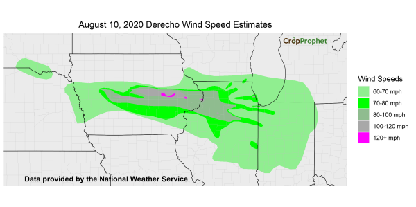
The derecho created wind speeds as high as 120 mph according to a National Weather Service analysis of the derecho. The extent of potential impacts from the derecho is shown below.
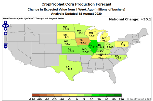
As discussed in a CropProphet weekly crop commentary, CropProphet’s response to the windstorm is limited to the impact of worsened USDA crop ratings, because CropProphet does not include weather predictors that directly capture severe storms (wind or hail). The USDA’s reported Iowa corn condition did worsen notably in the August 17, 2020 crop progress report, and CropProphet’s internal corn production model based on crop ratings dropped by 50 Mb for Iowa. This loss will increase in the next few weeks but the “official” CropProphet forecast for Iowa will drop much less, because the crop condition model provides only about a third of the predictability at this time of year. In the past week, the CropProphet corn production forecast dropped by 13 Mb in Iowa but rose by 30 Mb on a national basis.

 Iowa Derecho – Previous Years
 Iowa Derecho – Previous Years
To obtain an independent estimate of possible losses in Iowa, we explored the historical database of severe storm reports from NOAA’s Storm Prediction Center; this database includes estimates of crop damage in monetary terms. Two previous events were identified that – according to the database – caused by far the largest documented wind damage to Iowa crops in the month of August in the past 20 years, and the corresponding county-level yield outcomes were examined.
Prior Derecho: 2009
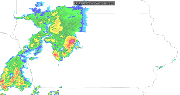
First, a very intense but localized storm migrated eastward across north-central Iowa on August 9, 2009, leading to both hail and wind damage in a row of six counties.
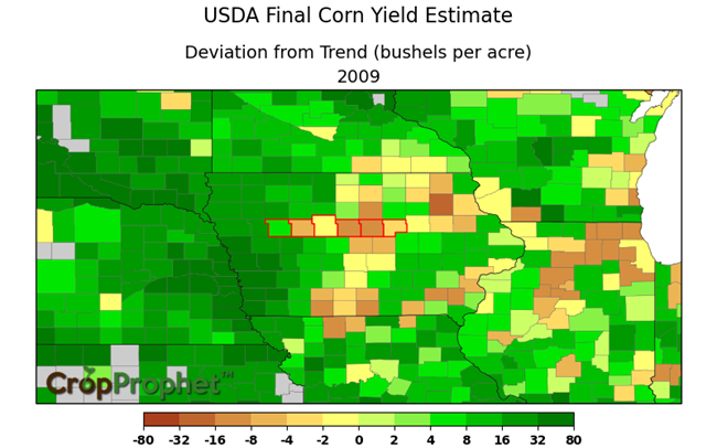
The second map below shows the 2009 county-level corn yield departure from trend, according to USDA final estimates, with the six affected counties highlighted. On average the yield in the six counties was 8.7% lower than in the directly neighboring counties, after accounting for trend differences, and the worst affected county saw a 13.5% drop in yield.
Prior Derecho: 2006
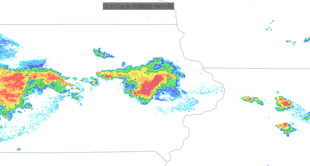
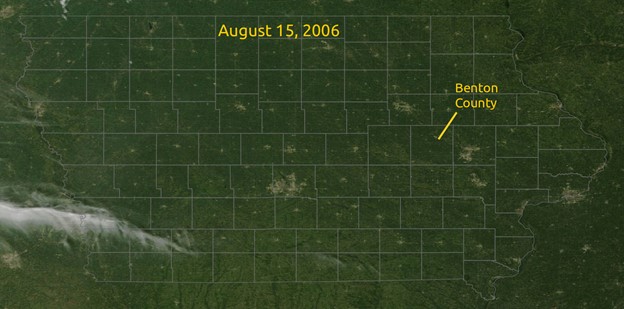
Second, severe wind damage occurred in Benton County, Iowa, in 2006, owing to a thunderstorm system on August 10. This storm system was more similar to this year’s August 10 derecho, with more wind than hail damage, although the NOAA database only includes damage reports for this one county.
The Benton County corn yield outcome was notably worse than in surrounding counties (see below), with an estimated yield reduction of 10.9%.
It is quite surprising that the county yield losses in these past events were only on the order of 10%, given that this year’s derecho is widely estimated to have caused much larger losses in the worst affected counties. Indeed, it is difficult to see how losses could be as low as 10% when corn is flattened at this stage in the season; but in all likelihood, the 2006 and 2009 events did not flatten corn across the entire area of the affected counties, or even in a majority of the area. For example, satellite imagery from August 15, 2006, shows no evidence of widespread damage in Benton County (see below); the damage was clearly much less severe than in this year’s event.

Impact of Iowa Derecho: 2020
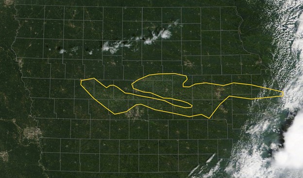
Based on satellite imagery from August 15 of this year (see below, provided by the National Weather Service), we estimate a total of 1.7 million acres of corn with severe crop damage in 21 Iowa counties that appear to be worst affected.
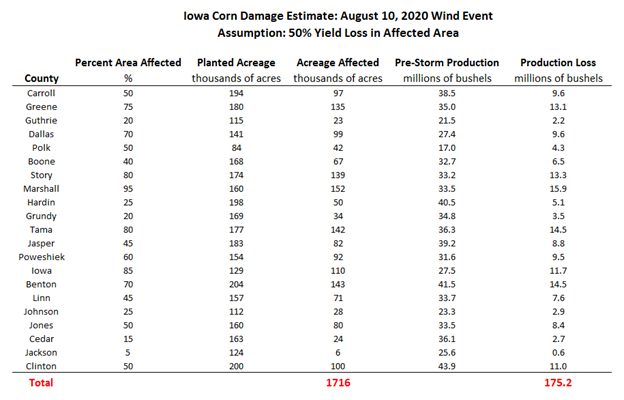
Using CropProphet’s county-level production forecasts to calculate potential losses, the maximum loss is 350 million bushels if all corn was lost within the affected acreage. A more reasonable estimate may be a 50% yield loss, or 175 Mb (see table below), with an uncertainty range of perhaps 90-260 Mb. The 2006 and 2009 events cited above would suggest a much lower yield loss ratio, but there seems to be little doubt that this year’s corn was all but destroyed in much of the acreage identified here as suffering the most severe impacts.
Additional corn losses occurred in other states, primarily Illinois and Indiana, but we have not attempted to estimate those losses. Although the thunderstorm system affected a wide area to the east of Iowa on August 10, it seems likely that losses were small in comparison to the damage in Iowa, both because satellite imagery did not reveal dramatic changes, and because other states’ USDA crop ratings declined much less than in Iowa. Moreover, the character of the storm system evolved as it shifted eastward, with storm damage becoming more isolated in association with locally intense pulses of severe storm activity and tornadoes, rather than the wide swath of severe straight-line winds that affected Iowa.
Iowa Derecho: Impact on Corn Yield
In terms of impacts to U.S. corn yield, a loss of highly productive Iowa corn will inevitably weigh on U.S. average corn yield, although if the highly damaged acreage is abandoned or withdrawn from the final yield calculation, then U.S. yield may fall only slightly. The same is true for Iowa’s state-level yield; the damaged counties were mostly higher-yielding counties compared to the rest of the state, so the state-average yield will drop, but acreage abandonment will tend to reduce this effect.
CropProphet provides weather-based corn, soybean, and winter wheat yield forecasts at the county, state, and national levels. Learn more about our solution by requesting a risk-free trial.