The 2019 growing season came to an abrupt end across large parts of the U.S. Plains and Upper Midwest between October 11 and October 14, 2019, as a dramatic early-season blizzard developed across North Dakota and unusual cold spread across many states. Snow accumulations of up to 36” occurred in North Dakota in tandem with very strong winds, and about half of the state was covered with at least 12” of snow. Northern South Dakota was also affected, and temperatures dropped well below freezing across most of the Northern Plains as well as parts of Iowa and Minnesota.
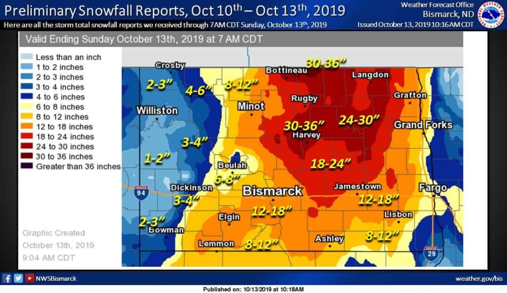
While October weather is often volatile in the Upper Midwest, and a first freeze is not at all uncommon in mid-October in the Northern Plains, the agricultural impacts of the snow and cold are potentially much greater this year owing to major delays in crop development. Ever since the excessive rain and flooding during the spring planting season, crop progress has been much delayed across the Corn Belt, and consequently, the crops have been in a vulnerable position with respect to an early (or even a normal) frost. The CropProphet yield and production forecasts have included a season-long “risk premium” related to the unusual spring weather and late planting, and unfortunately, the recent outcome has validated this concern.
While it is indisputable that the North Dakota blizzard and wider freeze have had at least some impacts on U.S. crop conditions and subsequent yield and production, the magnitude of the damage is quite uncertain. Ordinarily, during the growing season, the CropProphet weather regression models provide quantitative estimates of yield and production impacts caused by unusual weather, but CropProphet is not designed to revise its predictions during the harvest season, and the 2019 forecasts have already stopped updating for the season. In lieu of new CropProphet forecasts, this document seeks to estimate potential yield and production losses for corn-based on USDA crop progress information and CropProphet county-level weather data.
The first step in the analysis is to document the weather conditions. As illustrated above, there were extreme snowfall amounts in North Dakota, and it is likely that a heavy burden of wet snow combined with stress from very high winds (up to 65 mph) caused some physical damage to corn plants. Yield losses will occur from fallen ears or broken corn stalks, and harvest may be very challenging or impossible in water-saturated fields even after the snow melts; some acreage may be abandoned entirely. It is very difficult to say how great these losses will be, and we do not attempt to make any quantitative estimates related to the impacts of the snow.
A more detailed analysis is possible with regard to freezing impacts on immature corn. Freezing temperatures occurred in two rounds across the key corn-growing areas, as illustrated in the two figures below. First, a wind-driven freeze occurred across the Northern Plains and much of Iowa in association with the intense low-pressure system that was centered over northern Minnesota on October 11-12; the circulation brought cold air south from Canada and then transported it east towards the Mississippi River valley. Secondly, a more traditional hard freeze with light winds occurred on the night of 13-14 October, and in this second round, the minimum temperatures were considerably lower in eastern South Dakota, southwestern Minnesota, and northwestern Iowa.
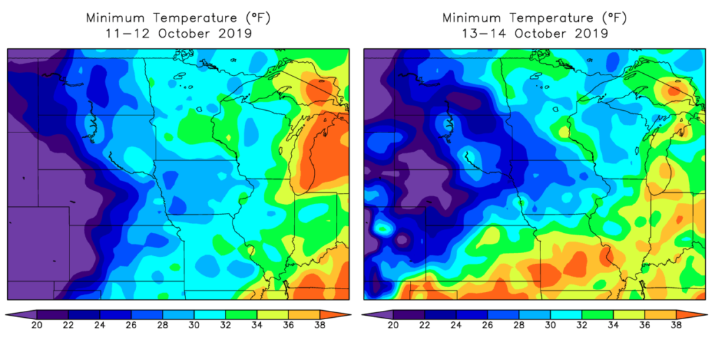
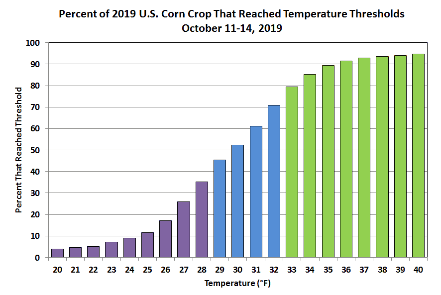
The threshold for a killing freeze is often cited as 28°F (-2°C), and this criterion was met for 35% of the U.S. corn crop on at least one day, based on CropProphet’s daily county-level weather data and our most recent county-level production forecast. The identification of counties that experienced 28°F or lower is used as the basis for the first estimate of potential corn losses below (“Scenario A”). However, a different estimate (“Scenario B”) is also developed that recognizes the high likelihood of a killing freeze at slightly higher temperatures during the windy conditions of October 11-12. In particular, parts of northeastern, central, and southern Iowa never reached 28°F, but on the morning of October 12 a temperature of 30°F occurred for several hours with a strong breeze, and this likely produced the same lethal effects on corn as a more severe freeze with no wind. Interestingly the same is true of eastern North Dakota, where extensive cloud cover and wind kept temperatures above 28°F throughout the event, but the wind-driven cold was probably still lethal for corn.
Corn yield losses can also occur at more marginal temperatures that cause non-lethal damage. We assume that this occurred in all other counties where the temperature dropped to 31°F; this occurred across an additional 26% of U.S. corn production, for a total of 61% that likely experienced some frost damage (see figure below).
The second step in the analysis is to estimate the maturity of the crop in the areas affected by frost. For this, we use the state-level USDA crop progress data, which includes the state-level percentage of the crop that is dented and mature. We use the data from the October 15 report (valid for October 13) to represent the maturity level at the time of the freeze, but we also use the previous few weeks to estimate how much of the crop was in the first, second, or third week after denting. The period of approximately three weeks between denting and full (black layer) maturity is when the “milk line” progresses to the tip end of the kernel, and frost-related yield losses are highly sensitive to timing within this period, as discussed here:
https://www.agry.purdue.edu/ext/corn/news/timeless/FrostFreezeImmatureCorn.html
Based on this article, we estimate percent yield losses under lethal freeze conditions as follows; we assume an exponential drop in yield loss as the crop progresses from dented to mature.
| Not yet fully dented | 40% |
| Post-dented week 1 | 27% |
| Post-dented week 2 (“half milk-line”) | 12% |
| Post-dented week 3 | 5% |
| Mature | 0% |
For non-lethal frost damage, we use the following yield losses:
| Not yet fully dented | 27% |
| Post-dented week 1 | 16% |
| Post-dented week 2 (“half milk-line”) | 6 % |
| Post-dented week 3 | 2 % |
| Mature | 0 % |
Finally, using the fraction of production in each state that experienced either a simple frost or a lethal freeze, we calculate the combined production loss from all development stages. It should be noted that we use the latest USDA harvested acreage estimates to convert production loss to yield loss. The results for Scenario A, assuming that only counties with 28°F or lower experienced a lethal freeze, are as follows.
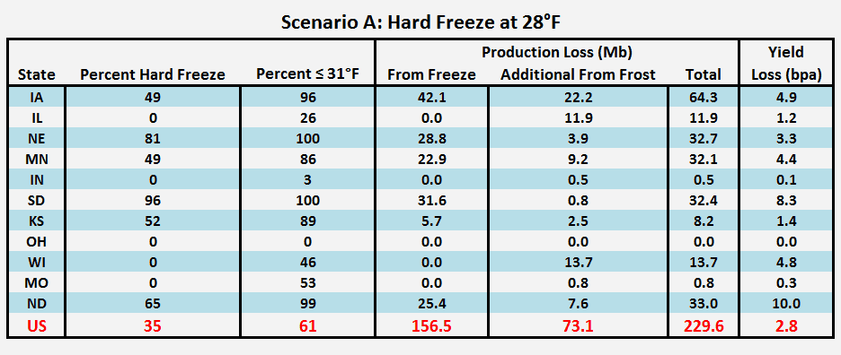
The largest production losses by some margin are found in Iowa, where we estimate that 64 million bushels (2.6%) were lost in the frost and freeze of October 11-14. In this scenario, about two-thirds of the Iowa loss was from lethal freeze damage, and the remaining one-third was from less severe frost. Significant frost/freeze losses of about 32-33 million bushels also occurred in each of Nebraska, Minnesota, and South and North Dakota. On a national basis, the likely production loss was 230 million bushels or 1.7% of the national crop; the U.S. yield is reduced by 2.8 bushels per acre.
Under the alternative assumption that lethal freeze damage was more widespread in the first round of wind-driven cold, the loss in Iowa rises to 78 million bushels (3.1%, or 6.0 bushels per acre) owing to the marginal conditions on the morning of October 12. The North Dakota loss also rises slightly, and the U.S. loss increases to 249 million bushels, which is equivalent to a yield loss of 3.0 bushels per acre.
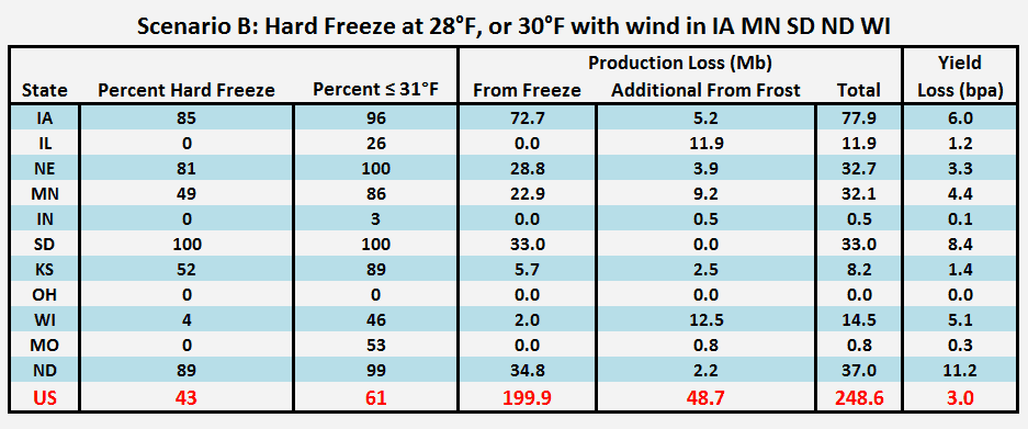
The greatest uncertainty in these estimates is the sensitivity of yield to the level of maturity for corn that was fully dented but not yet mature. Given that the majority of the frost-affected corn was within 7-10 days of black-layer maturity, there is obviously strong sensitivity to the assumptions that are made about yield impacts in that very last stage of development. We have assumed an exponential decrease in sensitivity as maturity approaches, but slight changes to the method could produce significant differences in the results.
Additional caveats should be noted. First, we only use frost and freeze data from October 11-14, and we ignore a freeze that affected a small fraction of North Dakota and High Plains corn at the beginning of October. Second, the USDA crop progress data is limited to state averages, and there are certainly variations in crop maturity across states; for example, the north-central district in Iowa is less mature than the rest of the state, and therefore it must have suffered slightly greater yield damage. Other districts are ahead of the state average. Finally, our analysis excludes the potential impact of acreage abandonment in the snow-affected areas of South and North Dakota. With the USDA estimating nearly 500 million bushels of corn production in North Dakota as of their October report, any significant abandonment would have a large impact on the net losses caused by the recent weather. Moreover, if North Dakota producers abandon acreage, then those poor-yielding areas will be removed from the national yield aggregation, and the final U.S. yield will be slightly higher than it otherwise would be.
In summary, the October 11-14 cold outbreak in the north-central U.S. is estimated to have caused corn production losses of 230-250 million bushels (2.8-3.0 bushels per acre) from frost and freeze damage alone. Additional significant losses may occur in the Dakotas owing to subsequent harvest difficulties caused by the impacts of heavy snow and high winds. The USDA is likely to reduce its corn yield and production estimates in future months as the scale of the damage becomes clear.