What is ag weather?
Ag weather, short for “agriculture weather,” is the term used to comprehensively indicate the impact weather has on the agriculture industry and the information used to make decisions to manage those impacts.
The use of weather information in agriculture has many applications. For example:
- An agricultural producer will look at precipitation and wind forecasts for the next 24 to 48 hours to plan fertilizer applications. The producer seeks to minimize costs by not having to fertilize a 2nd time if it’s washed off the crop by rain. Likewise, the producer seeks to spray a fertilizer only when the wind speed and direction are such that the droplets won’t drift onto a neighbor’s fields.
- A grain elevator will monitor weather conditions over the past few days to months to estimate the grain yield near their elevator. The elevator wants to ensure it secures sufficient grain volume to fill it’s elevators and minimizing revenue risk. The basis of the grain in their local market varies with weather conditions.
- A grain trader uses information from the 12Z NOAA GFS weather forecast model update to trade fluctuations in grain futures prices that occur as the model is released at 11 AM central time each day.
- Weather-based grain yield forecasters such as CropProphet use weather information including precipitation, temperatures, soil moisture, and related weather forecast information to forecast county, state, and national grain yields allowing grain traders, agribusiness, and hedge funds to manage risk while maximizing the opportunity of expected price changes.

Examples of Ag Weather from CropProphet
CropProphet quantifies the impact of weather on grains to benefit the trading portfolios of grain traders. We use historical weather and crop yield and production data to quantify the impact of weather has on crop yield and production. We present the information in contextually relevant ways.
Observation Based Ag Weather
Ag weather information is gathered from a variety of sources, including ground-based weather stations, satellite imagery, weather radars which measure precipitation, and dynamical weather forecast models such as the ECMWF model.
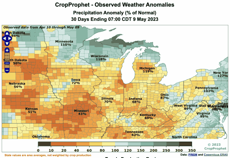
The information below shows precipitation over the past 30 days for the Midwestern US as of May 9, 2023. The average over the prior 30 days is compared to the precipitation over the same 30 days but averaged over the prior 30 years. The variable presented is the percent of normal precipitation. As can be seen, the prior 30 days has been quite dry in some parts of the western corn belts with rain totals reaching only 40 to 50% of normal precipitation.

Ag Weather Forecast
An ag weather forecast is a specialized weather forecast that is tailored specifically to the needs of the agriculture industry. In the case of CropProphet, ag weather forecasts provide information about weather patterns and their expected impact on grain yield.
Ag weather forecasts are derived from weather forecast model information sourced from national and international weather modelling centers such as NOAA and the ECMWF. The information typically input to the initial conditions of the forecast models include ground-based weather observations, satellite derived information, weather radar data, and radiosondes. The forecast information provided includes temperature, precipitation, humidity, wind, and solar radiation, and are designed to help grain traders make informed decisions about the likelihood of changes in market expectations of grain supply.
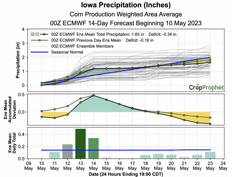
An example ag weather forecast for Iowa is below. The ECMWF precipitation forecast has been weighted according to the total average corn production in Iowa. The forecast, issued on May 10, 2023 shows precipitation is likely in the next few days across Iowa.

CropProphet focuses on predicting national level supply for corn, soybean, and winter wheat. As a result, the application of ag weather is primarily applying weather conditions to a model that relates daily weather conditions to end-of-season USDA corn yield estimates.