Excessive rainfall has occurred across much of the Plains in the past two weeks, as an extremely stormy weather pattern has prevailed in the central US and the lower Mississippi River valley. More than six inches of rain has fallen in most of central and southern Kansas and northern Oklahoma, with much of this occurring in the past two days.
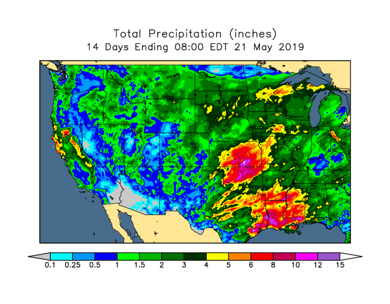
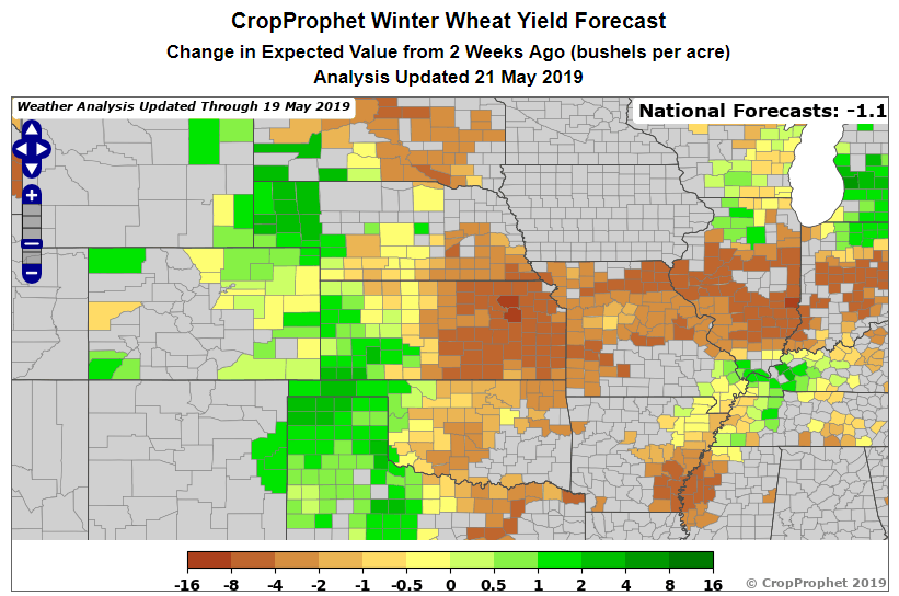
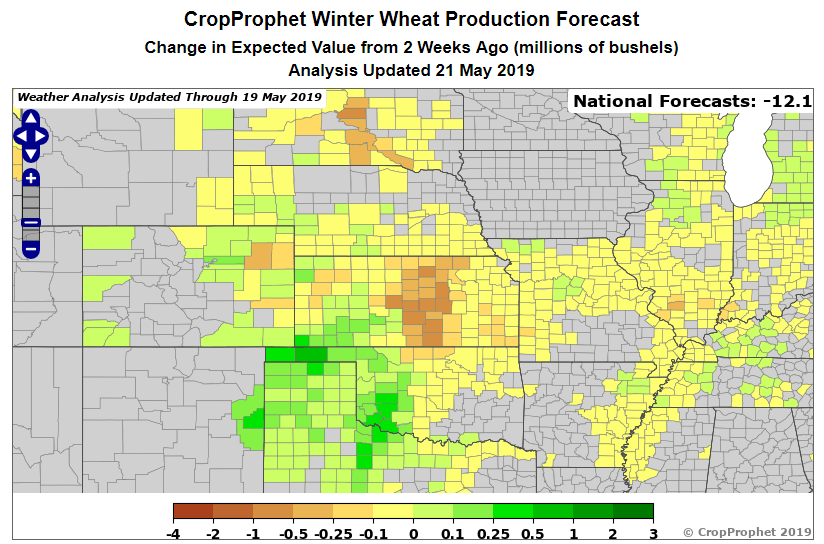
As anticipated in this commentary two weeks ago, the excessively wet weather of recent days has occurred across some of the most intensively cultivated winter wheat districts of the central US, leading to concerns about impacts on wheat production. The two-week change in the CropProphet forecasts shows yield declines of 5 bushels per acre or more in eastern Kansas, and there has been a notable decline in expected production in central Kansas. However, CropProphet also shows that the more moderate wet conditions in the High Plains have produced positive changes for yield from western Nebraska to the Texas panhandle.
The CropProphet yield forecast for Kansas currently stands at 43.6 bushels per acre, although it should be noted that this does not yet include the impacts of the latest extreme rainfall event, because there is a two-day lag in the rainfall data used by CropProphet (to allow for delayed reporting and quality control). The forecast is likely to drop rather significantly over the next few days as the rainfall data are updated. Interestingly, however, the USDA crop ratings for Kansas do not yet show any hint of negative impacts from the wet weather; indeed, the ratings improved in the latest weekly report. CropProphet uses the USDA crop condition data as a state-level predictor, but the county weather regression models are more valuable and contribute more heavily to the CropProphet forecast.
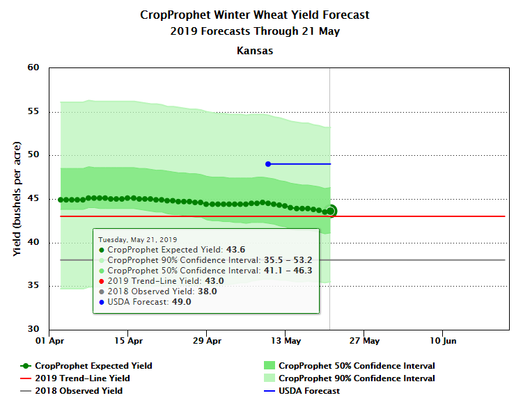
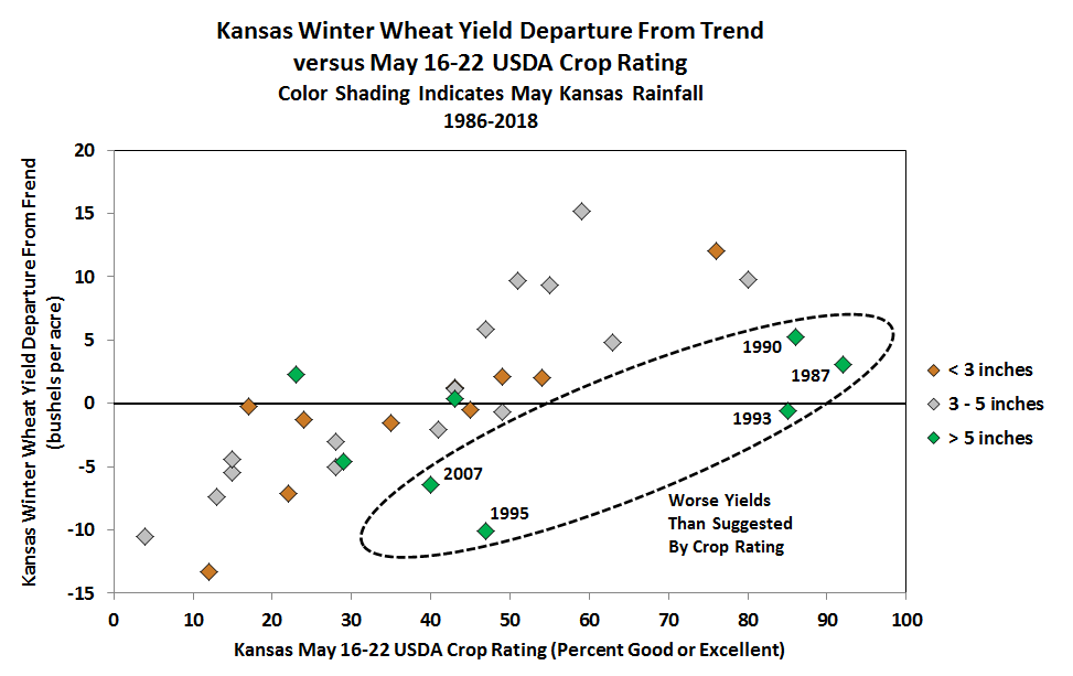
The vital importance of using independent weather predictors is illustrated by a historical analysis of the USDA ratings for Kansas winter wheat at this time of year; see the chart below. In general, higher crop ratings correspond to higher yields, but the relationship is seriously hampered by a lack of correlation in years when May is wet. The green markers on the chart correspond to 8 years when May was very wet (more than 5” of rainfall for Kansas as a whole), and in 5 of those years the final yield was considerably lower than would be expected based on the mid-May crop rating alone. This suggests that the USDA ratings often fail to account for the negative impacts of very wet weather at this time of year, and this may reflect a tendency for wet weather to promote yield-reducing disease in the remainder of the growing season.
Looking farther afield at the wider winter wheat crop, the CropProphet yield and production forecasts have deteriorated significantly in the northwestern states, including a 5.1 bushel per acre yield drop in Washington over the past two weeks. As in the Kansas forecast, the yield decline in the northwest is caused by the county weather regression models, and again the trend is contrary to a generally improving trend seen in the USDA crop ratings. However, unlike in Kansas, the weather models in the northwest are reflecting a lagged impact from the very cold start to spring rather than the effects of recent weather conditions. Both very warm and very cold weather in March are associated with reduced winter wheat yields in Washington, and future commentary will address this concern in more detail.